HOW TO GET TO BURNABY LAKE
- Burnaby Lake Walking Map
- Arriving by Transit
- Arriving by Car
- Arriving by Bicycle
Burnaby Lake Entrances
There are three main entrances to Burnaby Lake and its trails: Piper Street (where Piper Spit and the Nature House are located) via Winston Street, Avalon where you can access Cariboo Dam (via Cariboo Road), and Glencarin (via Kensington Avenue).
Walking
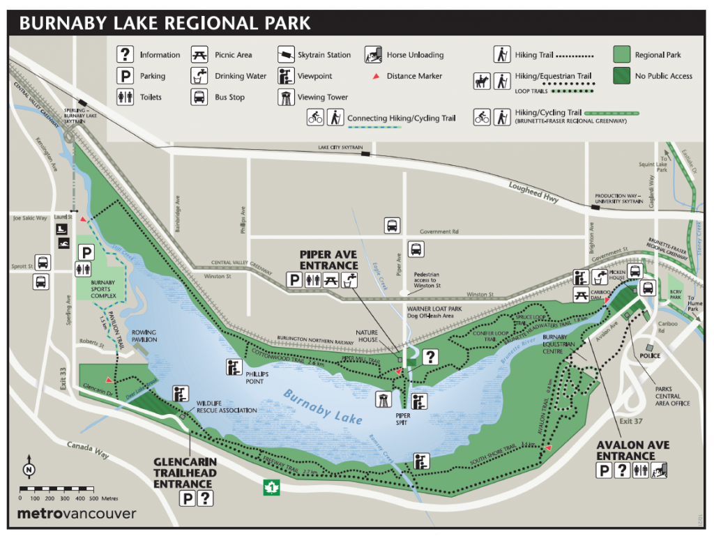 There is a large walking loop (approximately 10 km) around Burnaby Lake, along with several smaller side trails. Take a walking map of Burnaby Lake or full trail brochure with you or pick one up at the kiosks at Piper Spit (in front of the Nature House) or Avalon Parking lot at the trail entrance.
As with any trails, please pay attention to your surroundings for other walkers and runners (sometimes there are timed Fun Runs on the weekends). Be mindful of your safety – if you wear earphones, consider having the volume so you can still hear what is going around you or using one earbud only. Also, if you are at the east end of the lake, the Burnaby Horsemen’s Association stables are on Avalon Avenue so you may also encounter horses, ponies and their riders.
Please stay on trails to prevent disturbance to sensitve ecosystems and ground nesting birds and wildlife. Remember, Burnaby Lake Regional Park is a wildlife sanctuary, and located near Burnaby Mountain so you will see seasonal signs to be aware of wildlife (bobcats, bears, cougars) in the area.
Dogs must be kept on leash (and out of creeks and streams) for the safety of the wildlife and for them as well and follow Metro Vancouver Regional Parks Canine Code of Conduct. There is a leash free area at Warner Loat Park on Piper Avenue.
Transit
 There are transit buses that stop by either side of the lake and the sky train services the north side. Visit our Transit page to plan your trip.
Driving
There are three entrances to the park: Piper Spit, Avalon and Glencairn.
-
Piper Spit – Burnaby Lake Nature House
- Via Trans Canada Highway (Highway 1)
Eastbound or Westbound: Take Exit 37, for Gaglardi Way. Keep right. At the lights, turn right to get onto Cariboo Road. At the next set of lights, turn left to go north on Cariboo Road to the railway tracks at Government. Turn left and travel west along Winston and turn left onto Piper Avenue (flashing cross walk). Go to the end of the road and over the railway tracks. - Via Lougheed Highway (BC Highway 7)
Eastbound or Westbound: From Lougheed Highway turn south on Brighton Avenue. Go to the traffic lights and turn right. Go West along Winston and turn left onto Piper Avenue (flashing cross walk). Go to the end of the road and over the railway tracks. - There is limited parking in front of the Nature House including two Handicapped spots (tag required). Otherwise, parking along the side along Piper Avenue. If it is a really busy day, you may find spots past the railway crossing in Warner Loat Park closer to Winston Street.
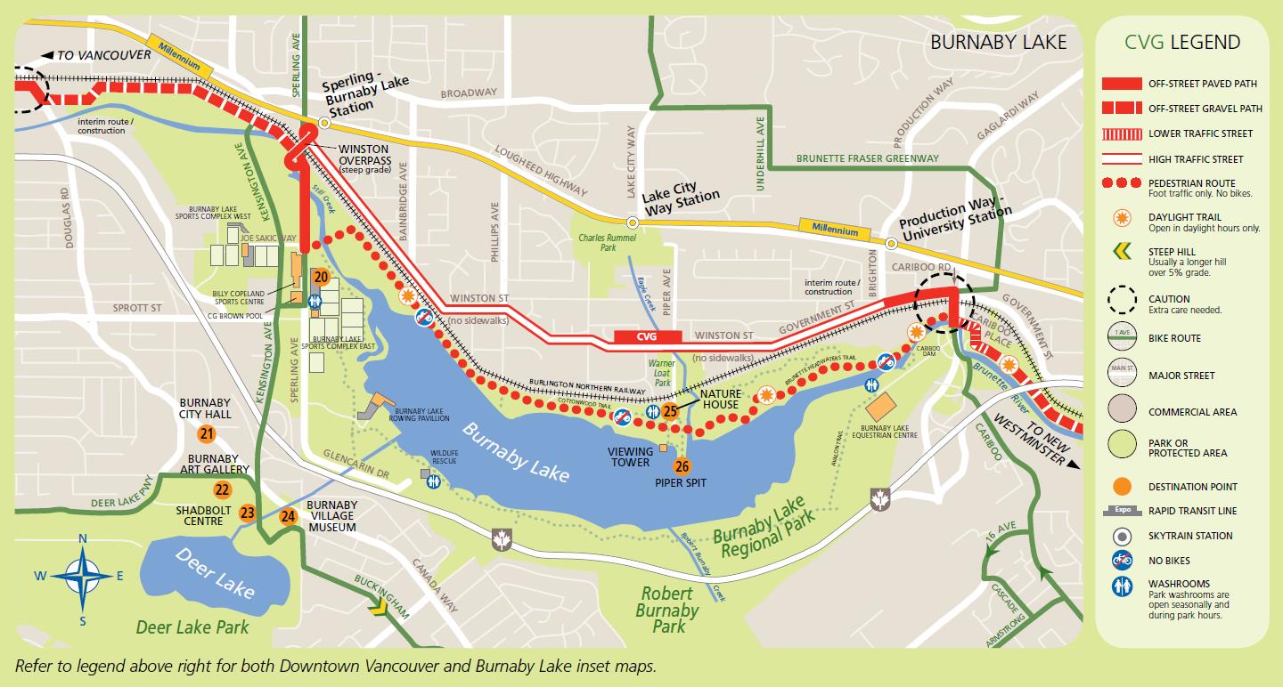
- * SPRING 2022 – late 2024: Please note that the Metro Vancouver Winston Street Sewer Project may have temporary lane closures and detours along Winston Street and Lougheed Highway as the project progresses. Bike detours and parking restrictions will be in effect near the work zones. Residents and businesses will be notified in advance about specific traffic impacts as the project progresses. Motorists and cyclists are advised to use alternate routes and follow the direction of signage and traffic control personnel. See map.
-
Avalon Entrance & Parking Lot – parking for Cariboo Dam
Via Trans Canada Highway (Highway 1)
Eastbound or Westbound: Take Exit 37, for Gaglardi Way. Keep right. At the lights, turn right to get onto Cariboo Road. At the next set of lights, turn left to go north on Cariboo Road. Just beyond the overpass, turn left at Avalon Avenue. Drive past the horse barns on the left and you will see see the sign for the Avalon Entrance. The parking lot is just past the sign to your right. .Via Lougheed Highway (BC Highway 7)
Eastbound or Westbound: Take Exit 37, for Gaglardi Way exit towards Highway 1. Turn left to Cariboo Road and turn left at the stoplight to stay on Cariboo Road. Just beyond the overpass, turn left at Avalon Avenue. Drive past the horse barns on the left and you will see see the sign for the Avalon Entrance. The parking lot is just past the sign to your right. .From Government Street: Turn onto Cariboo Road and cross the rail road tracks. Cross over a small bridge over the Brunette River and turn right onto Avalon Ave.
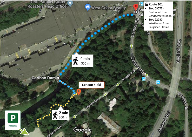
Lenson Field Restoration Site / Garage – also Cariboo Dam
This stewardship location is a 2 minute walk from the Avalon parking lot, or 4 minutes from the bus stops on Cariboo Road, or 20 minute walk from Production Way-University Skytrain Station (1.5 km – Brighton Avenue, left at Government Street, right at Cariboo Road).
-
Glencarin Trail
- Via Trans Canada Highway (Highway 1)
Eastbound: Take Exit 32, for Sprott Street. At the lights, turn left to cross over the highway overpass and stay in the right lane. Cross Kensington and at the stop sign, turn right at Sperling Avenue (past the Tennis Club) and it will veer left and turn into Glencarin Drive. Continue until the road ends and there will be a small parking lot at the Trail Entrance.
Westbound: Take Exit 33 for Kensington Avenue North. Turn right at the traffic light at Sprott Street. At the stop sign, turn right at Sperling Avenue (past the Tennis Club) and it will veer left and turn into Glencarin Drive. Continue until the road ends and there will be a small parking lot at the Trail Entrance. 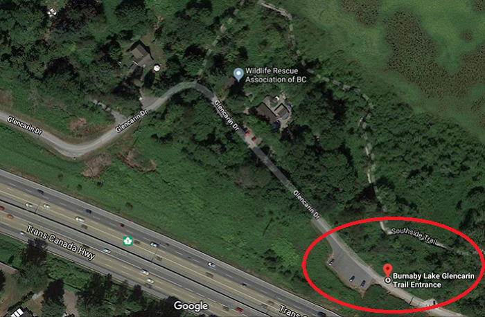
- You can also park at the sports fields parking lot and walk into the park.
-
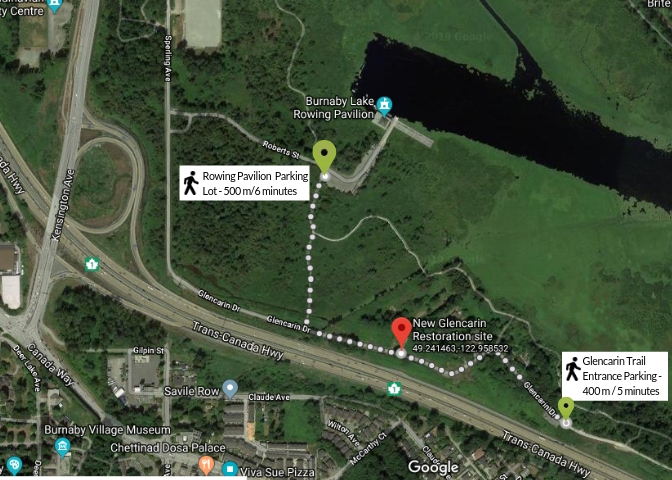
Glencarin Work Site
- This is a restoration site that doesn’t have parking right at the site itself. If we’re working there, look out for BLPA signage. If you are walking in from Sperling, please be careful as there is only a gravel edge. Parking is a short walk from the Glencarin Trail Entrance or Rowing Pavilion parking lots.
-
-
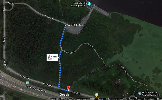
Deer Lake Brook Restoration Site
This restoration site does not have a street address nor an actual parking lot right at the site itself. It is located approximately 350 meters after Sperling Avenue turns into Glencarin Drive (type in 4500 Sperling Avenue in your map app.) If we are working there, look out for BLPA signage. There is a pull out area at the red pin in the map below that has room for a few cars, or you could park at the side of the road. If you do not wish to park on the road, you can also park at the Rowing Pavilion parking lot if it is not closed for an event, and walk the trail to the site. If you are taking transit and walking in from Sperling, please be careful as there is only a gravel edge.
Other locations:
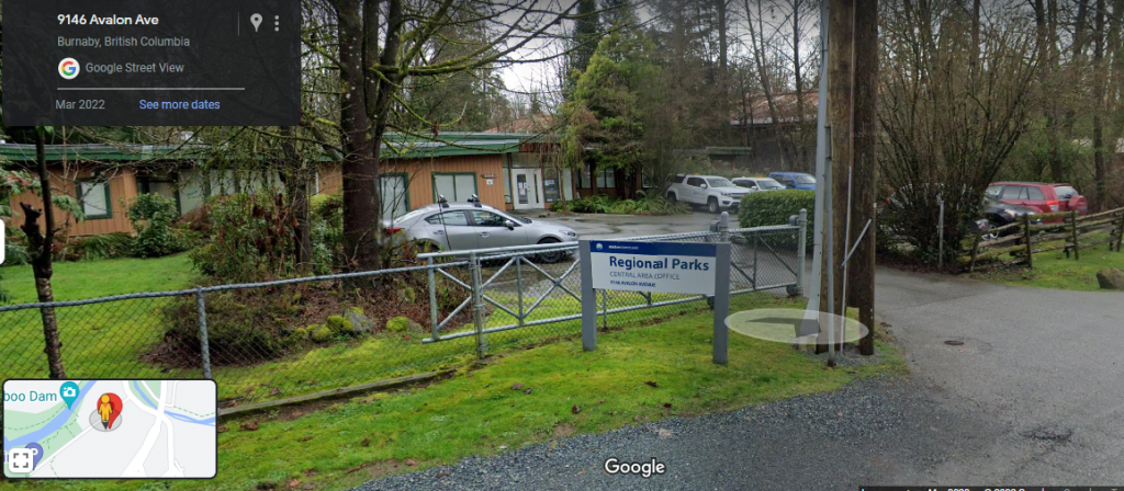
Metro Vancouver Regional Parks Central Area Office – 9146 Avalon Avenue
From Cariboo Road, turn onto Avalon Street, the office is 110 meters to your left.
Burnaby Lake Rowing Pavilion
Via Trans Canada Highway (Highway 1)
Eastbound: Take Exit 32, for Sprott Street. At the lights, turn left to cross over the highway overpass and stay in the right lane. Cross Kensington and at the stop sign, turn right at Sperling Avenue (past the Tennis Club). Drive past the sports field and turn left on Roberts Street.
Westbound: Take Exit 33 for Kensington Avenue North. Turn right at the traffic light at Sprott Street. At the stop sign, turn right at Sperling Avenue (past the Tennis Club). Drive past the sports field and turn left on Roberts Street.
Via Lougheed Highway (BC Highway 7)
Eastbound: Take the Kensington Avenue exit (past Garden Works). At the stoplight, turn left onto Joe Sakic Way which will veer right and turn into Sperling Avenue. Drive past the sports field and turn left on Roberts Street.
Westbound: Take the Kensington Avenue exit; turn right at the Chevron gas station then get into the left lane. At the stoplight, turn left onto Joe Sakic Way which will veer right and turn into Sperling Avenue. Drive past the sports field and turn left on Roberts Street.
Bicycling
Sorry, bicycles are NOT allowed on any of the trails around Burnaby Lake. This is due to the narrower width of the trails, blind corners and sensitive ecosystems along the walking trails. The closest bike trail is along Winston Avenue which is part of the Central Valley Greenway. There is a bicycle rack in front of the Nature House so you can park and walk on the trail.
For more information about cycling in Burnaby, check out the City’s website here. and the Burnaby Bike Map updated April 2023.