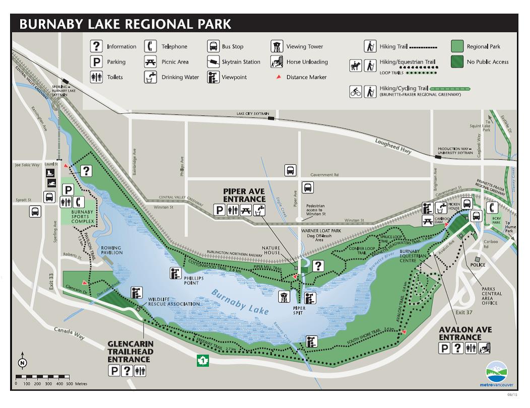
If you are taking transit to Burnaby Lake Regional Park, here are the key locations and bus stops. Enter Skytrain station or bus stop number into Translink trip planner to plan your trip to Burnaby Lake Regional Park.

SKYTRAIN STATIONS: You can walk into the park from the following Millennium Line stations:
Sperling-Burnaby Lake Station and Production Way-University Station.
NATURE HOUSE: 4519 Piper Avenue
The closest bus stops are on Route 110 – along Government Road.
Stop 52548 – Eastbound from Metrotown Station
Stop 52557 – Westbound from Lougheed Station
Get off at Piper Avenue and walk south for four blocks. At Winston Street, there will be a cross walk with a flashing light; cross and continue past the railway tracks to the Nature House.
You can also take the Skytrain to Lake City Station. Leave the station and cross Lougheed. Walk east and just past the Burnaby Works Yard you should see a staircase going down. Follow it to Piper Ave. Walk all the way along Piper (walking south) until you get to the Nature House and the lake. You will pass the flashing crosswalk at Winston Street and the railway tracks. (1.4 km walk, Approx. 16 minutes.)
AVALON ENTRANCE:
The closest bus stops are on Route 101 – along Cariboo Road
Stop 52267 – Eastbound from 22nd Street Station
Stop 58180 – Westbound from Lougheed Station
Get off at Avalon Avenue and walk up the road. You will see a sign for the stables to your left, past the Metro Vancouver Central Area Office and BHA stables on your left, and eventually you will see the park sign to your right.
Metro Vancouver Regional Parks Central Area Office – 9146 Avalon Avenue
From Cariboo Road, turn onto Avalon Street, the office is 110 meters to your left.
 Alternatively, there are Route 101 bus stops closer to the Pedestrian trail that goes along the north side of Cariboo Dam (approx. 4 minutes)
Stop 59577 – Eastbound from 22nd Street Station
Stop 52280 – Westbound from Lougheed Station
You can also take the Skytrain to Production Way Station. Leave the station and cross Lougheed. Walk south along Brighton Street past Costco, and cross the street and turn left at Government Street to Cariboo Road. Turn right and go past the railroad tracks. There is a pedestrian trail entrance to your right if you want to get into the park directly. To get to the Avalon Entrance or Metro Vancouver Central Area Office, keep walking to Avalon Avenue which will be on your right. (1 km walk, Approx. 13 minutes.) The parking lot is a further 300 m and another 3 minutes.
SPROTT STREET:
The closest bus stops are on Route 110 or Route 144
Stop 58720 – Eastbound from Metrotown Station via 110 or 144
Stop 52569 – Westbound from Sperling-Burnaby Lake Station via 110
Walk past the Burnaby Tennis club to your right, the Burnaby Lake Rugby Club is directly ahead. If you want to get to the Glencarin trailhead entrance, turn right and walk along Sperling Street to the east. Please be careful as there are no established sidewalks and the road will flood after heavy rainfall.
Use Google Trip Planner on Translink to find your route.
